
Pemberton Cycling Association

Gravel rides.

Pemberton sits in the middle of a very large amount of unsealed road. Eleven routes are mapped here, from a 21 km loop past the Gloucester Tree to a 115 km run to the coast - karri forest, farmland vistas, old logging highways and the occasional fire track.

11 routes 810 km mapped Free GPX
Riders on an unsealed forest road through karri country near Pemberton

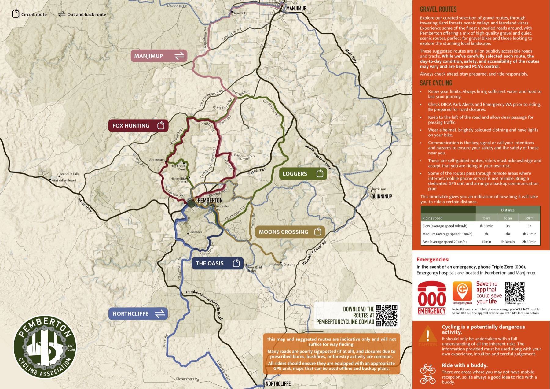
The map, on paper

The club's gravel route map covers the six rides below, with elevation profiles, surface splits and the local knowledge that does not fit on a screen. Free to download, and free to take from the Visitor Centre.

Tap either page to read it full size, or take the whole thing with you.

Download the mapPDF, 1.7 MB, A3 double-sided

Printed copies are available at the Pemberton Visitor Centre while they last.

The six on the map

Shortest first. Every map below is live - drag it, zoom it, or open the route in Ride with GPS to send it to a head unit or phone. No account needed to look, a free one to download the GPX.

Ride 01 · CircuitThe Oasis

20.8 km340 m climb66% unsealedMax grade 8.0%

A short, scenic loop past the iconic Gloucester Tree and up the picturesque Glauders Road, a route steeped in the history of Pemberton's early settlers. It finishes with a brief highway sprint and a descent through the valley on Conte Road.

The perfect introduction to Pemberton's gravel riding, with a few punchy climbs to get the legs working. Craving a little extra? The detour to the Cascades adds a scenic stop and another hill.

Ridden clockwise.

Ride 02 · CircuitFox Hunting

35 km546 m climb49% unsealedMax grade 9.0%

As the name suggests, this one leads out of town via Fox Road and scenic sealed farm roads before hitting the popular Smiths Road climb and descent. It brings you back through the karri trees on world-class gravel, passing the serene Big Brook Arboretum.

You finish up on Stirling Road, rolling past the Pemberton MTB Park. A blend of gravel and sealed roads with views over farmland and karri forest.

Ridden anti-clockwise.

Ride 03 · CircuitMoons Crossing

38.3 km577 m climb83% unsealedMax grade 8.1%

A classic Pemberton ride that takes you out the back of town to the scenic Moons Crossing, then back via Collins Road and the Munda Biddi. A mix of gravel roads with a touch of fire-track excitement on the return leg.

If your legs are up for it, the short detour to the River Road Bridge is a must-see.

Ridden anti-clockwise. The most unsealed of the six.

Ride 04 · CircuitLoggers

52.6 km785 m climb49% unsealedMax grade 9.3%

Wide-open gravel on the historic logging highways of Gloucester Road and Palings Road, heading back to town on Smiths Road and the Tramway Trail, rolling past the stunning Big Brook Dam.

If you have time, a leisurely spin around the sealed path at Big Brook is a must. It is a shared-use trail and quite popular, so ride with care.

Local's tip: if singletrack is on the cards, the Munda Biddi switchbacks behind the Gloucester Tree are a thrilling alternative to the Burma Road descent and climb.

Ride 05 · Out and backNorthcliffe
(Quokka Run)

77.8 km1,094 m climb80% unsealedMax grade 10.6%

An unforgettable out-and-back that winds through wildly different country, from towering karri groves and sweeping farmland to glimpses of the coast. Take a break and refuel in Northcliffe before turning for home.

Keep your eyes peeled - riders lucky enough on this one have been treated to the rare sight of quokkas in the wild.

Ride 06 · Out and backManjimup

86 km1,101 m climb66% unsealedMax grade 7.3%

Head to the big smoke for your morning coffee. A classic route that takes advantage of the quieter local sealed and unsealed roads, connecting with the Munda Biddi and passing through historic Deanmill.

From there it joins the Heritage Trail, an old rail corridor that offers a smooth and scenic ride into Manjimup. If you have the legs, the Manjimup All Day route below does the same trip the long way.

All-day epics

Five more that were too saucy for the printed map. These are long days in country where the phone will not help you. Caution advised - they are not for the faint hearted or the unprepared.

Epic 01Gin and Tonic

69.7 km1,070 m climb66% unsealedMax grade 13.1%

Quite a direct route out to Ampersand Estates. The 200 m-plus descent and climb in and out of the estate is a great hangover cure.

Not an extremely long ride by the standards of this list, and a great way to get out and enjoy the local sights for a day.

Epic 02 · One wayPemberton to Nannup

91.5 km1,241 m climb76% unsealedMax grade 13.1%

An epic ride from the lush karri forests of Pemberton to the gravel-rich landscapes of Nannup. A mix of gravel highways and picturesque single-lane roads, concluding with an exhilarating sealed descent into Nannup.

Finishes in Nannup, not Pemberton. Arrange the ride home before you set off.

Epic 03 · LoopManjimup All Day

99.5 km1,411 m climb48% unsealedMax grade 12.8%

To Manjimup and back the scenic route. A nice mix of sealed and unsealed roads as you meander through the changing landscape.

Wrap up the adventure with a loop around Big Brook and a thrilling descent down Thompson's Hill back into Pemberton.

Epic 04 · One wayPemberton to Walpole

115.3 km1,659 m climb90% unsealedMax grade 11.6%

Why not make your way to the coast? A captivating journey with ever-changing landscapes and a varied elevation profile. By the time you reach Walpole you will be ready for a dip in the inlet to celebrate.

The longest unsealed stretch on this page - 90% of it - and it finishes in Walpole. Plan the return trip first.

Epic 05 · LoopManjimup & Karri Valley

123.1 km1,811 m climbMostly unsealed

The longest route the club has mapped: north to Manjimup, then home the long way through Karri Valley. Over 1,800 metres of climbing across the day.

Not on the printed map, and the only one here without a write-up. Check the profile before you commit.

Three more, without the GPX

Local rides the club has never put on Ride with GPS. There is no route file and no elevation profile for these - just a description and a map to read yourself. Worth knowing about anyway.

Big Brook Dam loop

~17 kmFamily friendly

A classic Pemberton loop via the Rainbow Trail, past Forest Fresh Marron and around the dam.

At around 17 km it is the shortest ride on this page.

Gloucester Tree loop

~30 kmBig karri country

South via the Gloucester Tree, returning on Gloucester Road and the Munda Biddi Trail.

It passes the Gloucester Tree, as The Oasis above does - and that one is mapped, if you would rather set off with a route file.

Munda Biddi connector

VariousTrail

Pemberton sits halfway along the 1,000 km Munda Biddi Trail. Ride north to Manjimup or south to Northcliffe, as far as the legs and the daylight allow.

Munda Biddi Trail →

Prefer tarmac? There are eight road routes mapped the same way, from a 25 km lap to an 86 km tour of the south-east. The Pemberton MTB Park is a separate world again.

Before you ride

  • These are self-guided routes. Riders must acknowledge and accept that they ride at their own risk.
  • Know your limits, and carry enough water and food to last the journey.
  • Check DBCA Park Alerts and Emergency WA before you set off. Road closures are common.
  • Keep to the left and allow clear passage for passing traffic. Signal your intentions.
  • Wear a helmet and bright clothing, and run lights.
  • Some routes pass through remote areas where mobile service is not reliable. Bring a dedicated GPS unit and a backup communication plan.
  • Ride with a buddy. There are stretches with no reception at all.

The map will not navigate for you

These routes are indicative only and will not suffice for way finding. Many roads are poorly signposted, if at all, and closures due to prescribed burns, bushfires or forestry activity are common.

Carry a GPS unit, offline maps and a backup plan.

In an emergency

Phone Triple Zero (000). Emergency hospitals are located in Pemberton and Manjimup.

With no mobile coverage you will not get through to 000, but the Emergency+ app will give you your GPS location to pass on when you do.

The club has chosen these routes carefully, but their day-to-day condition, safety and accessibility vary and are beyond PCA's control. Always check ahead, stay prepared, and ride responsibly.

These routes are free. Keeping them mapped, printed and signed is not.

Join the club$25 a year, juniors $15