Mountain biking.
Pemberton is a mountain biking paradise. The trails wind through stunning karri forest, where the "Karri Gold" dirt offers a smooth and gripping ride - arguably the best in the state.
There are two separate networks in town, built by different people and riding quite differently. Both are below.

Pemberton Mountain Bike Park
The original network: 36 km of hand-built singletrack with timber drops, log rollers and flowing berms, on the hill above town. The trailhead is on Swimming Pool Road.
Cut and maintained by Pemberton Cycling Association volunteers, with the revamps built by Woodlands Trails, Sam Hill Signature Trails and Three Chillies Design. The park is community-owned, and supported by the Pemberton Visitor Centre and the Pemberton Caravan Park.
Open the list on the map for every trail, its grade and its current condition. The park on Trails WA →
How it rides
Hand-cut singletrack on a proper hill, and it asks more of you than the Arboretum does. Green through black, with timber features, wall rides, rock and root, and descents that reward knowing the trail. The climbs are real climbs.
Every trail is described on the club's printed map below, and Trailforks carries the day-to-day condition of each one.
Pump & Jump Track
Free and open to all at the park trailhead. Gentle rolling pumps, humps and corners on a looped circuit, with the dirt jumps alongside for riders who have progressed past them.
The map, on paper
Every trail in the park, described and graded, with the whole network drawn on the other side. Free to download, and free to take from the Visitor Centre. It covers this network only.
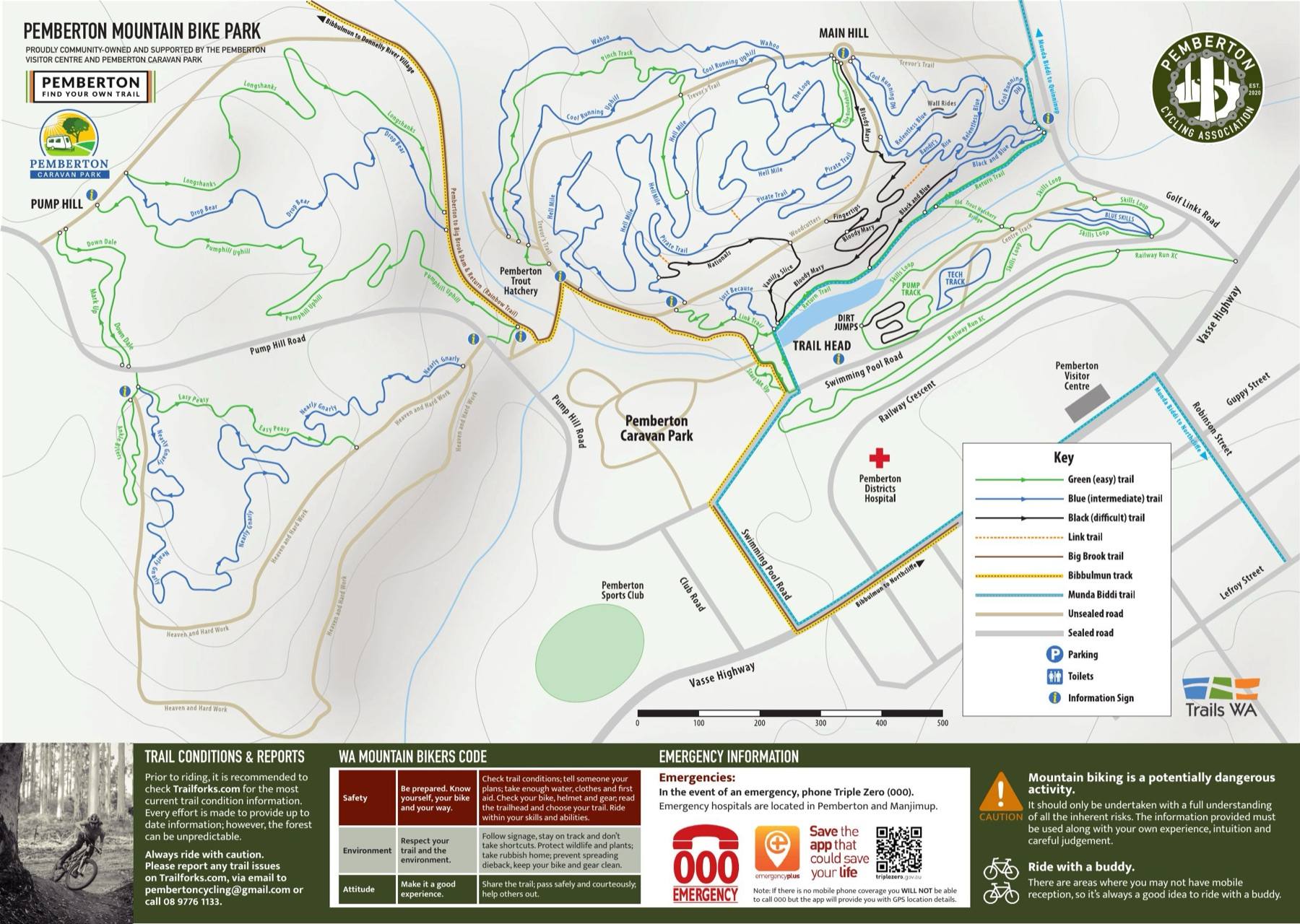
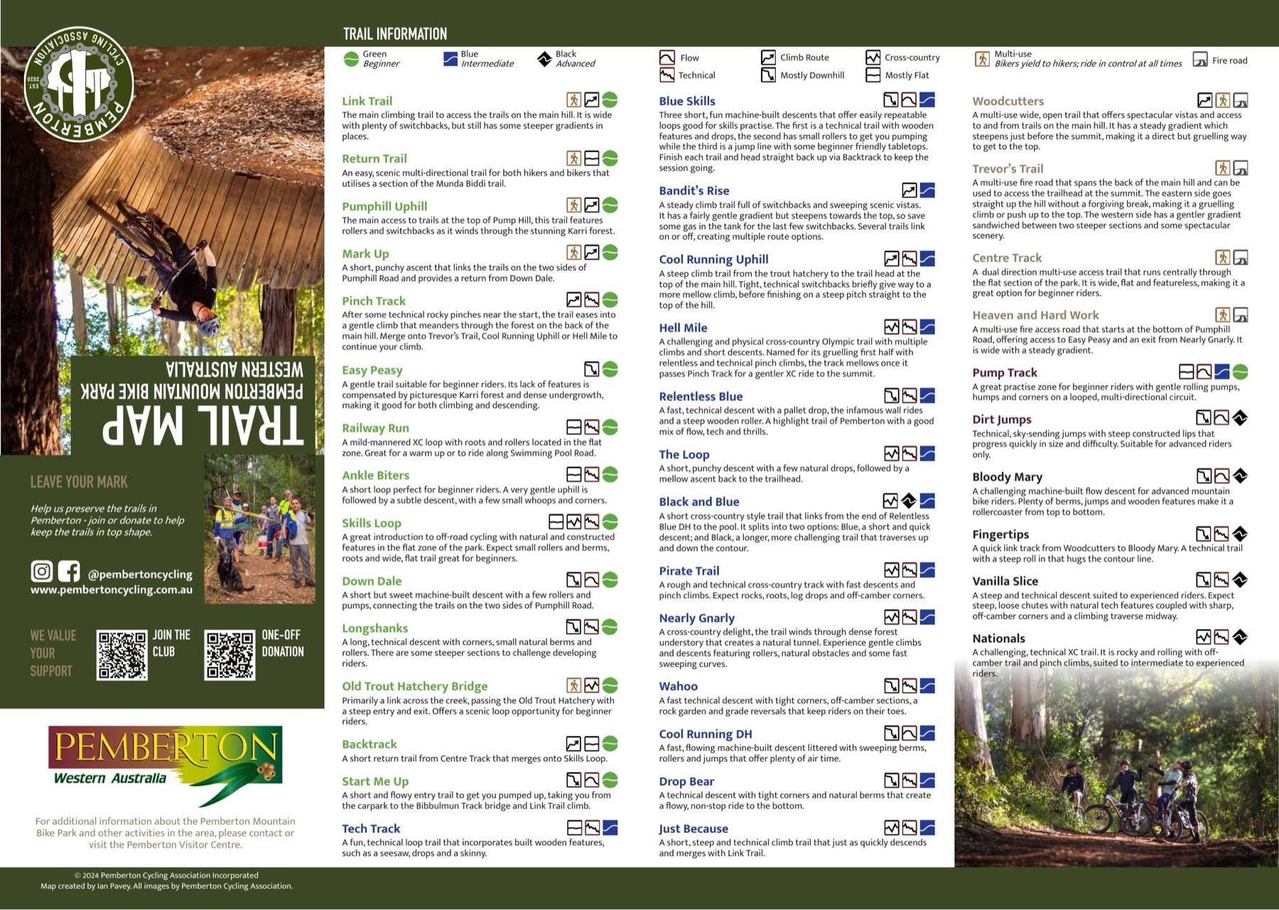
Tap either page to read it full size, or take the whole thing with you.
Download the mapPDF, 1.7 MB, A3 double-sidedPrinted copies are available at the Pemberton Visitor Centre while they last. Map created by Ian Pavey.
Every trail here was built by volunteers. Most of them are members.
Join the club$25 a year, juniors $15The Arboretum
The new network: around twenty kilometres of machine-built flow trail through the Arboretum Forest, off Vasse Highway. It was built by DBCA rather than by the club.
It rides nothing like the park, and that is the reason to go.
Open the list on the map for every trail, its grade and its current condition. The Arboretum on Trails WA →
How it rides
Where the main hill is hand-cut, steep and technical, the Arboretum is machine-built and forgiving. Short trails, smooth surface, bermed corners, and gradients that never get away from you. Mostly green and blue, with a handful of blacks for later.
Which makes it the best place in Pemberton to ride with kids, or to put someone on singletrack for the first time.
Built for progression
Everything threads around one car park, so a nervous rider is never far from the start and nobody has to commit to a long climb to get a run in. Laps are short enough to repeat until a corner finally clicks.
The grades sit alongside each other rather than in separate corners of the forest, so you can step up from green to blue, and eventually to the blacks, one trail at a time and without leaving the network.
No club map for this one
The club's printed map covers the park only. Use the map above or the Trails WA page, and take the usual care - the Arboretum is newer than the park and still bedding in.
The dirt does not stop at the park boundary. There are eleven gravel routes and eight road routes mapped out of Pemberton too.